Diamond Land Surveying, LLC
Laser Scanning (LiDAR)
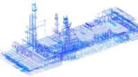
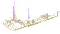
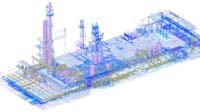
3D laser scanning, also known as Light Detection and Ranging (LIDAR) provides highly concentrated 3D data points of existing site features. Together the data points are referred to as “point clouds.” By using a laser pulse to measure directly to an object, physical contact with that object is not necessary. Thus, 3D laser scanning makes field data collection safer and less intrusive on the daily operations of a site or facility. For example, the need to access busy highways, overhead utilities, or active machinery is eliminated. Also, because of the enormous amount of data collected, 3D laser scanning can reduce site investigation from weeks to hours, saving time, which results in project cost savings to the client.
The 3D laser scanner itself has two components: a digital camera and a laser. First, the operator takes a picture with the digital camera, then marks the area to be scanned. Next, the laser scanner rotates robotically to capture data at an incredible speed of up to 4,000 points per second or more. This rapidly reduce data collection time while also increasing the level of the detail in the data gathering. Once the points are accumulated, the data is merged and produces a raw image. This raw image is then migrated into 3D visualization software and design tools, which gives engineers and surveyors greater design power and capabilities and will allow clients to visualize before construction what the finished product will look like.